
Transylvania represented
When looking at East Park in Cluj through the lens of macro-geographics, we see similarities with the wider region of Transylvania, a low-lying landscape surrounded by the Carpathian Mountains. In miniature, Parcul Est is historically meadowland, protected by higher banks on its boundaries.
To imagine East Park as a miniature region within the European subcontinent, with its range of landscapes, and associated conservation goals and objectives, would serve to create a living model of best practice in land management and conservation for visitors and also help to galvanise the importance of nature protection in people’s minds.
It would set this park apart from others internationally, as an example of how wild nature can thrive as the heart and lungs of a modern European city.
It would set this park apart from others internationally, as an example of how wild nature can thrive as the heart and lungs of a modern European city.
Lake 3 protected area
The western Lake is a key area of the park, characterized by the lake and its shores and forming part of the arrival experience. Taking the mini-region analogy, this area would be considered a mini ‘Protected Landscape’ (IUCN Category IV), containing a miniature ‘Strict Nature Reserve’ (IUCN I) on its western shoreline and a miniature ‘buffer zone’ containing two ‘responsible development zones’ and on its northern and southern shores.
The main approach to the park from the west is along the southern bank of Lake 3, which makes its way down the highest slope on the site. This is where the challenge of creating a universally accessible footpath arises: steps to the bottom of the lake for pedestrians, a fluid shape shared cycle and pedestrian path on the top platform, gently sloping down to the core of the park where a shared vehicular and cycle connection merge to form the entrance plaza.
The interaction with the water is mediated by three circular platforms. The first of these is on the southern shore, surrounding a circular boat house, where canoes, kayaks and rowing boats can be hired or stored for club use. A smaller social platform on the north shore provides seating which overlooks a small swimming area demarcated with floating buoys or markers. The largest platform will be on the eastern edge, opposite the entrance plaza. This will be a circular sculptural feature that will be used to walk out onto the lake to experience the water and offer open views across the lake.


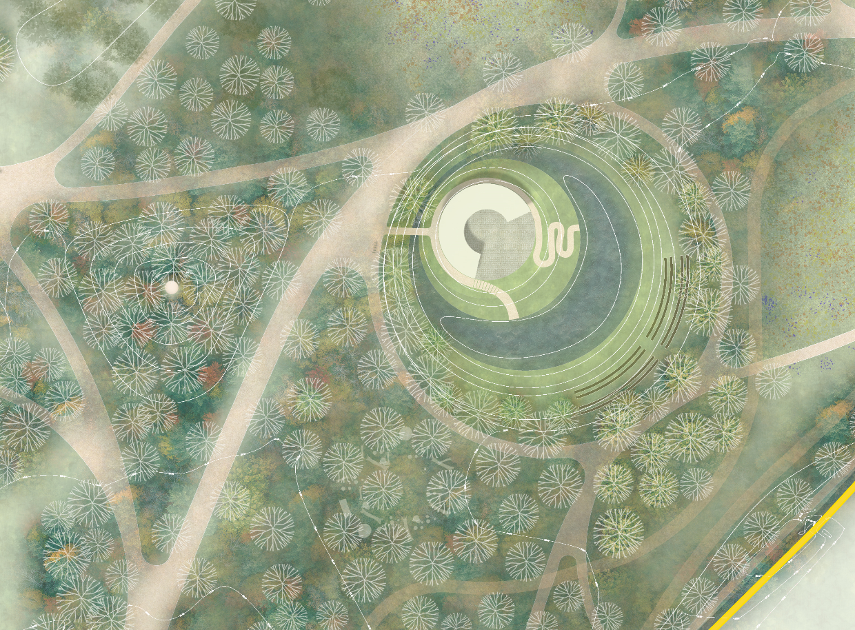
Entrance Plaza
The main entrance will be located at the ‘convergence point’, where each of the different micro-geographical territories of the park meet. This provides a unique opportunity for the entrance of a park to also be its energy centre and its heart. To celebrate this idea the entrance will be marked by a landmark structure, a pavilion, that melts into the landscape through the tree line.
This energy centre will have the potential to become an important destination point for the city and beyond. The Pavilion could be a multicultural melting pot where a range of diverse activities originate at the core of the park, creating not only a powerful sense of identity for the park, but also a functional access point to each of the designated areas: it provides controlled access to the protected areas, a welcoming meeting place for visitors, a place of shelter and replenishment, an educational and recreational resource for the community, and by its very appearance, it will be a striking addition to the area that is integrated into the landscape.


The Nature Reserve(protected area)
The northern area of the main body of the park is an existing area of high biodiversity, and an area that deserves to be protected and controlled to maintain and enhance its current capacity to harbour a diverse spectrum of living organisms.
As part of the mini-territory concept, this area of the park and its wider buffer zone will be designated as a mini-National Park (IUCN Category II). Most of the protected area within it will fall under the strictest protection as a mini-Nature Reserve (IUCN Category I), where visitation will be controlled by restricted access, limited mainly to raised boardwalks and bridges with associated railings to keep people on the designated routes. Small areas within this zone will be designated as responsible development areas where eco-friendly construction processes can provide appropriate facilities for community use.
A raised walkway will be routes around the perimeter of this area, providing a fluid experience with loop walks, temporary stopping places, platforms, bird watching and observation towers, microflora view areas, and short sections where the walkway enters into and integrates with protected wetland features such as the wetland forest and areas of standing water.
This area of the park will be a dark zone, with limited lighting provided only at entrance areas. To visit this area will be like entering a wild and untamed landscape where one's senses are activated to appreciate the full array of nature’s wonders. Raised walkways will be provided to offer added protection to landscape so that visitor impacts are minimised. Railings and balustrades will be provided at various levels and intensities depending on the amount of protection needed in different areas.
A link will be provided from the future Expo park and Somesul Mic River to the Wetland Park and through the centre of the strictly protected Nature Reserve. This route will be sensitively designed with natural materials and installed up high on stilts to allow movement corridors for fauna, it will be enclosed allowing open views but with secure balustrades on both sides, used only as a transitioning path across this strictly protected zone.
The area, identified as a strict Nature Reserve, will be surrounded by a buffer zone forming the mini-National Park. This will resemble the Somesul mic River path throughout the city of Cluj-Napoca, surrounded on both sides by native trees, creating a sense of enclosure and protection.
The public garden
Like in the wider area of Transylvania, the remainder of this mini-territory will be an ‘undesignated landscape’, resembling typical common areas under eco-responsible community use and management. It will be both an oasis and an interlacing of experiences (leaf veins) punctuated with nodal points of activity (oxygen bubbles).
It will have two main components: a semi natural buffer zone, where expansion of the protected area will take place, and its active centre, the cultural landscape.
Within the Semi natural buffer areas, eco-responsible interventions will take place by replicating aspects of the adjoining Nature Reserve, for example, through excavations (with raised ground water levels) or by reworking the drainage channel system, inspired by historical site maps and wetland enhancement methods. The difference with this area, compared to the Nature Reserve, is the freedom to experiment with ecological enhancement techniques where the public can interact, allowing its visitors and interested groups to feel like they are part of this dynamic ecosystem.